Click on picture for satellite map from
USATF and Google Earth
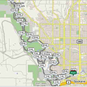
Marathon Course
The route starts on Spokane Falls Blvd and Howard at Riverfront Park and proceeds west to Monroe. Runners will cross Monroe carefully and turn right onto Riverside. At Oak, turn left and head south to First. Turn right on First Ave, then turn left on Poplar. Turn right on Pacific and then turn left on S. Coeur d'Alene St. Follow the route along the summit and follow it to the right and down the steep hill on S. Coeur d'Alene St. Turn right on Sunset Blvd and cross over the bridge. Turn right on Government way running for about two and a half miles to the Military Cemetery. At the Cemetery runners will be routed right onto the Centennial Trail on a long, paved, downhill back to Ft. Wright Drive. Runners take the right fork of the trail, running up the Fort Wright Drive hill to Elliott Drive. Turn right and continue up the Elliott hill onto the back side of the SFCC campus. After cresting, the hill veers left. Stay on the road along the softball field to the main entrance to the track. Stay on Elliot as it veers left. Then continue to Ft. George Wright Drive and turn right. Run one block and turn right on Randolph Road. Go to Freemont Road and turn left. Stay to the right on Fremont at the Y and continue on to N. Wright Drive. The road turns into dirt as you run past the National Guard maintenance shop. The road then continues back to the Military Cemetery.
Once back at the Military Cemetery, you will be routed left and head west on the Centennial Trail. This section is very winding, with short but steep hills. At about mile 9.5 runners come out on to N. Audrey White Park Drive and meet a “significant hill”. The next four and a half miles are winding, downhill, and rolling along the Spokane River to the 7-Mile bridge. After crossing the bridge, runners turn immediately right on to Aubrey White Parkway, which will follow the Spokane River back into town past Riverside State Park. This turns in to Downriver Park Drive. This section is particularly scenic as it winds along the river and past Downriver Golf Course.
The next hill is at mile 22 at Pettet Drive (Doomsday Hill). After cresting the hill (half mile) runners turn right on West Point and then right on Mission. Run along the edge of the west central neighborhood where Mission turns into Summit Blvd, and then Summit turns into Ohio. This ridge road is gravel. Ohio eventually goes to the left just after you pass under a railroad trestle. At this point, turn right onto Ide. At Monroe turn left and then immediately right onto Bridge St. Then turn left at Lincoln and run past Anthony's. Turn right at Mallon, and then continue to Howard just past the Arena. Turn right into Riverfront Park and follow the trail south across two bridges (the second blue bridge is the old Howard Street Bridge). Then turn right onto the final bridge just west of the Carrousel and just north of the fountain. The Finish is at the south of the southernmost lamp post on the bridge.