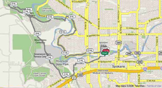
½ Marathon Directions
Start @ 1st parking meter east of Wall on Spokane Falls Blvd
Go west on Spokane Falls Blvd
Turn right on Riverside as you pass through the Monroe intersection
Go west on Riverside
Turn left on Oak
Go one block and turn right on First
Turn left on Hemlock
Turn right on Pacific
Turn left on Spruce
Go south on Spruce, past Coeur d 'Alene park and down the hill (Spruce joins and becomes Coeur d'Alene as you go down the hill)
Turn right on Sunset Blvd
Turn right on Government Way
Follow that for a couple miles (approx 2.5 miles)
Turn right on road to military cemetery
@ military cemetery turn left on Centennial Trail (going west- away from town)
Follow that to Trails Rd and turn left
Turn left on Government Way
Turn left on road to military Cemetery
This time when you go through the cross over, you go right (east) on Centennial Trail
When you get to the Y (just before the TJ Meenach bridge) go to the left
Go under the bridge
Circle around to the right onto the bridge
Turn right on the bridge (staying on the side walk)
Turn right on Pettet Drive (Go up Doomsday hill)
Turn right on West Point
Turn right on Mission
Follow that road (it turns into Summit and then Ohio)
Then turn right on Ide St
Turn left on Monroe
Then almost immediately right on Bridge St
Then left on Post St
Right on Mallon
When Mallon S's to the right (in front of the Spokane Arena), go left into Riverfront Park
Follow the trail south across two bridges (the second one is the Blue Bridge)
Then turn right onto the final bridge the one just west of the Carrousel and north of the fountain.
Finish is at the south of the southernmost lamp post on the bridge
Click on picture for satellite map from
USATF and Google Earth
